SPECIFICATIONS
Download the technical specifications below

Knowledge & Application Hub
Soartech LiDAR Products Application Hub brings together high-resolution LiDAR-derived datasets, expert insight, and practical guidance to support informed decision-making across industries. This platform is designed not only to showcase our curated geospatial products, but also to help users understand how LiDAR data can be applied, interpreted, and integrated into real-world workflows. Through a combination of visual data, technical context, and application-driven knowledge, Soartech aims to build confidence in the use of LiDAR technology and enable meaningful exploration of geospatial information.
From Research to Real-World Application: An Expert’s Journey with LiDAR

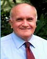
“LiDAR Visionaries; Dr. Kazimierz Becek with RIEGL Founder Dr. Johannes Riegl”
Professor.Kazimierz Becek (Senior Member, IEEE)
Faculty of Geoengineering, Mining & Geology of Wroclaw University of Science and Technology
He received his M.Sc. in land surveying from Wroclaw University of Agriculture, Poland (1978), a Ph.D. in geodesy from Dresden University of Technology, Germany (1987), and a D.Sc. (habilitation) in remote sensing from
the same institution (2010).
His research focuses on remote sensing and mathematical modelling of environmental systems, with particular emphasis on LiDAR technologies. Dr. Becek has extensive experience in the processing and analysis of Aerial Laser Scanning (ALS) point clouds,
including advanced studies of natural and anthropogenic environments for applications such as landslide monitoring, hazard assessment, and ecological analysis.
He teaches dedicated courses on Aerial and Satellite LiDAR and has delivered professional training on LiDAR data applications, including industry-oriented short courses. His work bridges academic research and applied LiDAR use in environmental monitoring and geospatial analysis.
After serving as a faculty member and lecturer at Universiti Brunei Darussalam, Dr. Kaz Becek transitioned from academia to industry by joining Soartech Systems Sdn Bhd as a Senior Geospatial Consultant, a role he held for over half a decade. During this period, he was instrumental in shaping Soartech’s geospatial and LiDAR capabilities, helping to bridge rigorous academic research with practical, industry-ready solutions. Dr. Becek played a key role in developing internal competencies, establishing robust LiDAR data processing and analysis workflows, and mentoring local engineers and analysts to build sustainable in-house expertise.
Beyond internal development, Dr. Becek led and delivered specialised training programmes in LiDAR processing, 3D analysis, and applied geospatial workflows for high-value industries and national stakeholders. His engagements included advanced training for Brunei Shell Petroleum, supporting safer and more efficient asset and terrain monitoring within the oil and gas sector, as well as capacity-building initiatives for the national survey department to strengthen institutional geospatial capabilities. Through these efforts, he contributed to the adoption of modern, data-driven practices across critical infrastructure and resource management domains. Dr. Becek’s long-standing collaboration with Soartech reflects a shared commitment to technical excellence, knowledge transfer, and the responsible application of LiDAR and geospatial technologies to deliver measurable value for industry and the nation.
Applied LiDAR & Geospatial Case Studies
This section showcases selected LiDAR and geospatial research studies published by Dr. Kazimierz Becek to demonstrate the real-world application, technical rigor, and industry relevance of advanced 3D data acquisition and analysis in supporting safer, smarter, and more efficient infrastructure and terrain monitoring.
Slope Stability Monitoring Using 3D Terrestrial Laser Scanning (TLS)


This study demonstrates how terrestrial laser scanning (TLS) can be used to monitor slope stability in open-pit mines by capturing high-resolution 3D point clouds of mine walls over repeated survey campaigns. By comparing scans acquired over time, engineers can detect millimetre- to centimetre-scale displacements, deformation patterns, and early signs of potential slope failure across the entire slope surface rather than only at isolated monitoring points. This full-field spatial insight allows operators to identify unexpected movement zones, assess risk more accurately, and make informed decisions on blasting schedules, evacuations, and slope remediation measures. While the accuracy of TLS depends on factors such as scan geometry, range, atmospheric conditions, and precise registration, the method provides a powerful, non-contact solution for improving safety and early-warning capabilities in large-scale mining environments.
Read the full study (PDF):
Off-Site / Autonomous Bridge Inspection Using UAVs and 3D Point Clouds


This research presents an automated workflow for bridge inspection using UAV-captured imagery and 3D point-cloud models generated through LiDAR or photogrammetry. High-resolution images are processed with deep-learning algorithms to detect structural defects such as cracks and surface damage, which are then projected onto 3D models to determine their real-world size and precise location. By fusing image analysis with point-cloud geometry, the approach reduces false detections and enables accurate measurement of damage extent. This method significantly reduces the need for hazardous manual inspections involving scaffolding or rope access, while providing repeatable, quantifiable records for asset managers to support condition-based maintenance and budgeting. Although data quality, lighting conditions, and regulatory acceptance remain important considerations, the workflow offers a safer, faster, and more efficient solution for inspecting critical infrastructure.
Read the full study (PDF):
LiDAR Dataset Keymap (Google Earth Visualization)

The keymap displayed above, provided by Professor.Kazimierz Becek, is presented via Google Earth to allow users to visually explore the spatial coverage of Soartech’s LiDAR-derived datasets, including Digital Terrain Models (DTM), Digital Surface Models (DSM), and high-density 3D point clouds. By opening the linked keymap in Google Earth, users can easily visualize the areas where LiDAR data is available and understand the extent of datasets currently held by Soartech. This visualization serves as a reference tool to help users identify their Area of Interest; once identified, datasets for the selected area can be requested and acquired through Soartech, subject to project requirements and data availability.
Note: Viewing the keymap requires Google Earth to be installed on your device. Google Earth is available as a free application from Google.
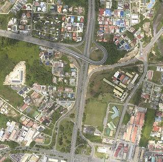
Orthophoto Gallery Access (PicDrop)
Soartech showcases selected orthophotos through a secure online gallery hosted on PicDrop, allowing users to preview high-resolution aerial imagery derived from our geospatial data acquisitions. The gallery provides a convenient way to visually assess coverage, image quality, and suitability for various applications before making a request. Access to the gallery is provided via the link below, where users can browse available orthophotos and identify imagery relevant to their Area of Interest.
How to Acquire Orthophotos:
-
Click the provided PicDrop gallery link to access the orthophoto gallery.
-
Browse the gallery and review the available orthophotos.
-
Note the label or reference ID shown on the image(s) of interest.
-
Send a request email quoting the image label(s) to bsb@soartechsystems.com.
-
Our team will follow up with availability, pricing, and delivery details.
Industrial Solutions & Applications of Orthophotos
how orthophotos are applied in real-world industrial scenarios to support planning, visualisation, and confident execution by aligning design information with accurate, ground-referenced imagery is demonstrated in the " INDUSTRY SOLUTIONS " section of the website
Refer to the Industry Solutions section for real-life applications of orthophotos OR Click on the Button Below
Orthophoto Technical Characteristics & Data Quality